
Planning a short adventure to Norway, want a challenge and some new terrain, time constraints are going to make it spicy, hoping for some help with feasibility/route planning.
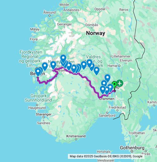
Day 1 – Oslo to Geilo
Day 2 – Geilo to Vossevangen
Day 3 – Vossevangen to Bergen
Going to follow the mountain route. By in large looks something like this:
https://www.google.com/maps/d/viewer?mid=1pCKBNRRyoVV-CJc-xIZLy-6FiKbhzQo&ll=60.536057351365784%2C7.750137522168265&z=8
Any thoughts?
Travel light, slap some 30mm on the road bike and go for it.
by Key_Entertainer9522
4 Comments
250km or so on the first day is spicy indeed. Especially if you get headwind and rain. But I don’t know you so maybe? Lots of people do stuff like Paris-Brest-Paris or the GDMBR, so anything is possible. Anyway, cyclenorway.com (and associated youtube channel) probably has some route info for you.
I can’t see your exact route in google but depending on how critical your time table for returning is, and how confident you are in making it, I wouldn’t go too remote. You could stay close-ish to the https://www.nor-way.no/en/ bus routes, in case you need to bail. Or the rail lines, vy.no
Ending up “out of gas” in a remote corner of the interior can put you at least a day away from any kind of cross country bus or airport /train, and long distance taxis are very expensive here (hundreds of euro). Most places have a local bus, but they may only run twice a day.
Sounds awesome though! We rode cross country (Haugesund to Oslo) last year, going more southern than you. Took us 6 days and killed me, but I’m not particularly extreme. Don’t know about feasibility for you, just don’t underestimate the mountains 😅 Hardangervidda plateau is pretty extreme, I know you’re probably skirting it to the north but just so you know. I have seen snow/slush rain in early July (above 1km over sea level).
Also check every tunnel you plan to use. There are a lot here and Google will route you through them regardless. Some of the major mountain ones are closed to cyclists, for safety (clearance, bad air). Other ones have a button on a sign that flashes, you must push it before entering so drivers are aware you’re in it! Look for a sign before, it will be very clear (“trykk / push here”, and a bike symbol)
You can do it! I did the opposite last year but took the more southern route via Stavanger and finished in Tønsberg. 5 days and the pace was comfortable. Crossing the islands to Stavanger had roughly the same elevation as the mountain crossings. Just in short sections instead of long tedious grinds. Plan ahead with food and snacks and there won’t be any problems. There’s plenty of services around and enough car traffic to help out in a catastrophe.
Haugastøl to Myrdal (Rallarvegen) on your route is a blast and so so pretty. I actually just uploaded it to Street View last week if you want to check how the gravel is on that road.
https://maps.app.goo.gl/a8wQMXv6fcWVU3ZHA
When are you planning to bike? There’s snow on Rallarvegen for a while longer. Most likely opened by end of june
https://www.haugastol.no/en/rallarvegen-report
Oslo to Geilo in one day is doable, but note the elevation.