
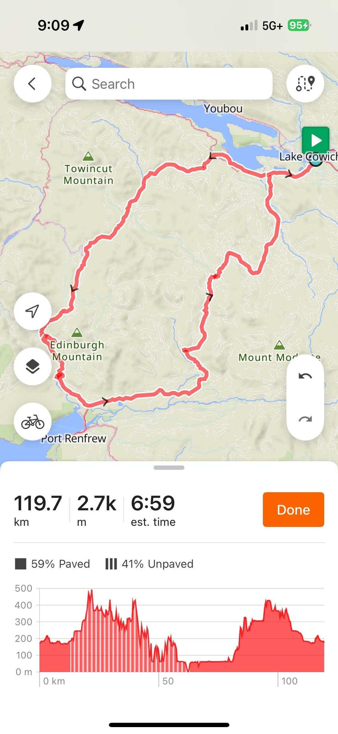
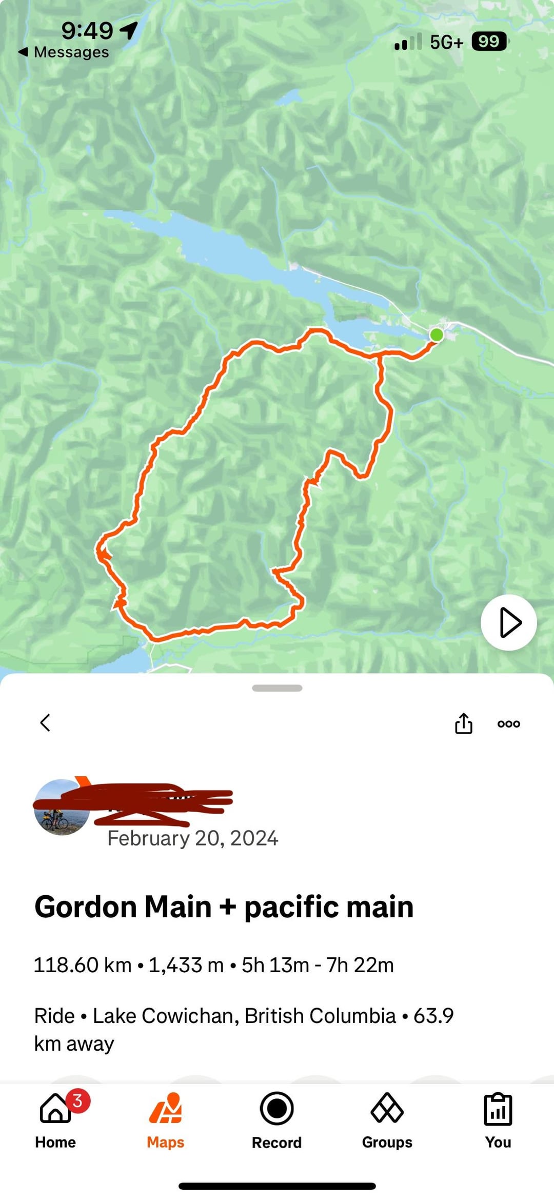
Any info regarding accuracy of different apps. I understand the inaccuracy in elevation and you should take it with a grain of salt, but 61% difference!?
by lifeof_lyle
Any info regarding accuracy of different apps. I understand the inaccuracy in elevation and you should take it with a grain of salt, but 61% difference!?
by lifeof_lyle
7 Comments
I always find the estimations are way lower than the actual tracked. I presume that’s because my smart watch is tracking minute elevation changes that aren’t picked up on a map.
Measuring total assent and total descent is similar to measuring the length of a coastline. The finer you measure it the more it gets.
See https://en.m.wikipedia.org/wiki/Coastline_paradox
Update. I asked ChatGPT and it told me to run it through a smoothed DEM data visualizer, through the GPS Visualizer website. It came back with 1,288m. That makes more sense. There could have been a bug through ridewithgps.
For this route, is it pretty easy to stay on gordon river rd? and not lose your way on the FSR’s?
I was excited to come in here and trash garmin’s elevation estimates, but I’ve actually had pretty good results with ridewithgps and strava. This seems like an extreme anomaly.
PS I’ve bikepacked around Lake Cowichan and it is beautiful! Trestle bridge and breakfast at Timmy H’s!
TLDR; it’s more complicated than it seems.
CW: wall of text, copy pasted from a doc on the topic
—-
## Elevation data and elevation calculation
Content warning: Rabbit Hole ahead.
### Preliminary:
There are differences between:
– elevation data coming from a route planner (in general, estimated with DEM public datasets)
– elevation data coming from a recorded route: depending on the device (presence of a barometer) and the origin of the file (directly from device or from “device + correction postprocessing through a platform like Strava”)
– Real world data (measurements from devices) is noisy and very diverse.
The difference between the sample rate of the device and the calibration/fiability of its measurements has an enormous influence on the computation of a cumulative metric like positive elevation / negative elevation.
### General
https://gis.stackexchange.com/questions/67449/how-to-determine-the-most-accurate-elevation-algorithm#answer-259508
https://www.gpsvisualizer.com/tutorials/elevation_gain.php
### Coros
https://support.coros.com/hc/en-us/articles/11432277964052-How-COROS-Devices-Measure-Elevation
### Strava
https://support.strava.com/hc/en-us/articles/216919447-Elevation
https://support.strava.com/hc/en-us/articles/115000024864-Strava-s-Elevation-Basemap
https://support.strava.com/hc/en-us/articles/115001294564-Elevation-on-Strava-FAQs
### RideWithGPS
https://support.ridewithgps.com/hc/en-us/articles/4419010957467-Grade-Elevation-and-GPS-Accuracy-FAQ
### Komoot
https://support.komoot.com/hc/fr/articles/360023082951-Donn%C3%A9es-d-%C3%A9l%C3%A9vation-d-altitude
A recent trip I took was supposedly 5k total ascent on ridewithgps, when I loaded up my garmin it said close to 7k! I guess just use the lower number when your huffing and puffing up the hill, use the higher number when you tell your buds