Does anyone else come back from a tour, and wonder why they did it?
I know I do. There’s so many reasons that make people go out on their bike. Heck, there’s a lot of reasons why I go out! And I’m not sure what the most important things are.
Maybe I’m over-thinking it. But I’ve recently had an experience that’s making me think. It was on a stage of my trip around the north coast of Scotland, heading towards Strathmore, a valley in Sutherland.
In this part of my two-week tour, I was following some of the NC500 route. But I was also thinking carefully about tips from some top redditors. The likes of u/Electric-Shoe , u/jeremywheels and u/sioranth have wisely encouraged others to find alternatives. And they’re right! the NC500 just has too many camper vans and crowds to be fun.
With all this in mind, I decided to take a diversion took from Tongue to Altnaharra, then back to the main road via Strathmore Valley and Hope. This was not an efficient choice: it added some 30 miles to the route, in rather hostile weather (as it turned out). But tor all the challenges, this became one of the most memorable highlights of the trip.
The weather forecast at midsummer was hard to believe.
In less than a week, the blue skies would cloud, the temperatures would drop, and we’d be lucky to get a single hour of dry weather a day. The weather map showed a vast front of heavy rain coming from the Atlantic. There was no way around it. Short of the Hebrides taking the major hit (if that’s even a thing?), weather was going to happen – soon.
So when the 27th of June rolled around, I knew I should make the most of the fine weather.
At the small coastal town of Tongue, a left turn lead me to hours of elevation via undulating terrain on the A836. For every little climb, there was an exhilarating downhill; and mercifully, for every stretch with headwind, there was a tailwind waiting around the corner. Everything worked together to make my cycling quick and fun.
As afternoon inched forwards, I was in no hurry to set up camp for the night. After all – the daylight was long, the weather was ok, and I was feeling great. So when I turned right at Altnaharra at 5:30PM, I didn’t pay much attention to the nice patches of dry and flat ground by the side of the road.
At that moment – ignorance was bliss. Minute by minute, i was getting lessons in the highland landscape. More specifically, I was learning that the track went through the biggest expanse of blanket bog in Europe.
Bogland had been making my life difficult already. I’d spent two nights inspecting patches of flat ground. I’d see a potential camping spot from the track, and go over to look more closely. Everything seemed fine, until I trod on it. Under pressure, boggy ground expresses more water than a sponge: and it would be no accommodation.
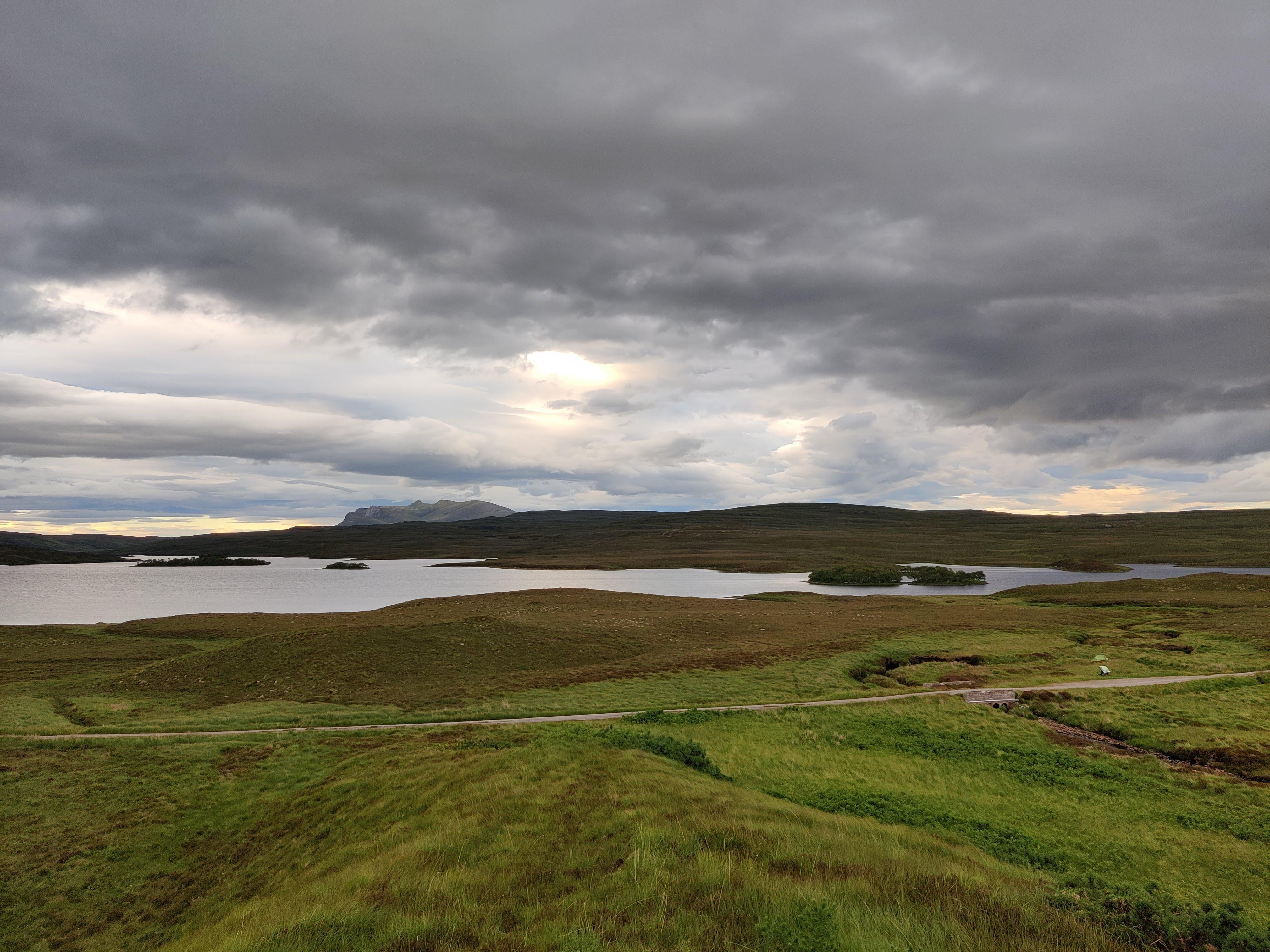
I didn’t think of this when I turned. But an hour on from Altnaharra, I was spent; and faced with bog, I was close to desperation for a little while. By some stroke of luck, I found a grassy spot by the road, with a fine view of Loch Meadie. I settled for the risk of cars passing, propped my bike up against a noticeboard commemorating the poet Rob Dunn, and settled in for the night. In the late light of 9:30, the windy afternoon weather settled into a menacing calm.
The midges were happy. They were here to stay for the night: so I made my excuses, zipped up my tent, and did what I could to sleep.
Radioactdave on
A map is not the territory it represents, but, if correct, it has a similar structure to the territory, which accounts for its usefulness.

2 Comments
**Part 1**
Does anyone else come back from a tour, and wonder why they did it?
I know I do. There’s so many reasons that make people go out on their bike. Heck, there’s a lot of reasons why I go out! And I’m not sure what the most important things are.
Maybe I’m over-thinking it. But I’ve recently had an experience that’s making me think. It was on a stage of my trip around the north coast of Scotland, heading towards Strathmore, a valley in Sutherland.
In this part of my two-week tour, I was following some of the NC500 route. But I was also thinking carefully about tips from some top redditors. The likes of u/Electric-Shoe , u/jeremywheels and u/sioranth have wisely encouraged others to find alternatives. And they’re right! the NC500 just has too many camper vans and crowds to be fun.
With all this in mind, I decided to take a diversion took from Tongue to Altnaharra, then back to the main road via Strathmore Valley and Hope. This was not an efficient choice: it added some 30 miles to the route, in rather hostile weather (as it turned out). But tor all the challenges, this became one of the most memorable highlights of the trip.
The weather forecast at midsummer was hard to believe.
In less than a week, the blue skies would cloud, the temperatures would drop, and we’d be lucky to get a single hour of dry weather a day. The weather map showed a vast front of heavy rain coming from the Atlantic. There was no way around it. Short of the Hebrides taking the major hit (if that’s even a thing?), weather was going to happen – soon.
So when the 27th of June rolled around, I knew I should make the most of the fine weather.
At the small coastal town of Tongue, a left turn lead me to hours of elevation via undulating terrain on the A836. For every little climb, there was an exhilarating downhill; and mercifully, for every stretch with headwind, there was a tailwind waiting around the corner. Everything worked together to make my cycling quick and fun.
As afternoon inched forwards, I was in no hurry to set up camp for the night. After all – the daylight was long, the weather was ok, and I was feeling great. So when I turned right at Altnaharra at 5:30PM, I didn’t pay much attention to the nice patches of dry and flat ground by the side of the road.
At that moment – ignorance was bliss. Minute by minute, i was getting lessons in the highland landscape. More specifically, I was learning that the track went through the biggest expanse of blanket bog in Europe.
Bogland had been making my life difficult already. I’d spent two nights inspecting patches of flat ground. I’d see a potential camping spot from the track, and go over to look more closely. Everything seemed fine, until I trod on it. Under pressure, boggy ground expresses more water than a sponge: and it would be no accommodation.
I didn’t think of this when I turned. But an hour on from Altnaharra, I was spent; and faced with bog, I was close to desperation for a little while. By some stroke of luck, I found a grassy spot by the road, with a fine view of Loch Meadie. I settled for the risk of cars passing, propped my bike up against a noticeboard commemorating the poet Rob Dunn, and settled in for the night. In the late light of 9:30, the windy afternoon weather settled into a menacing calm.
The midges were happy. They were here to stay for the night: so I made my excuses, zipped up my tent, and did what I could to sleep.
A map is not the territory it represents, but, if correct, it has a similar structure to the territory, which accounts for its usefulness.
— Alfred Korzybski, Science and Sanity