
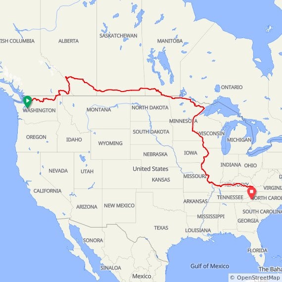
I'm looking to head along the Canadian border, West to East starting around mid-July. My idea is to ride mostly trans-canada trail until about Banff, and then from there mostly ride the trans-canada highway until around the great lakes.
It looks like the trans-canada would be a good ride, there is a race that goes on it, it has a lot of heat from bicycle heat maps, and street-view images show a good shoulder. Looks legit.
I'm looking at the Canadian border so closely because of summer heat, I'm hoping by being a bit more north it won't be as bad (I'm guessing I'll see some good summer temperatures, but hopefully better than compared to being in Colorado or similarly south like that).
Me: I'm quite tolerant for car traffic. The only thing that really bothers me about cars is the noise and exhaust fumes. For example, I really enjoyed riding Trans-Am in Montana.
My questions:
- Is the trans-canada highway actually very busy (*edit*, thinking of mostly the rural sections)? It looks like it goes through a lot of very remote land. In the US the interstates are pretty busy everywhere, but a lot of highways in remote areas are very low traffic. Is trans-can more like an interstate, or a remote highway? Is the road full of freight traffic? Full of people going between provinces/cities? I assume close to the cities it would get busy.
- Is Trans-Canada highway actually really scenic? The street-views looked good, but hard to tell how consistent that is. (*edit*) To clarify this question a bit, how is trans-canada highway as compared to a US interstate? US interstates are cool in the plains IMO, but otherwise it all looks the same (divided highway, hills on both side where the highway was cut into the land, repeat ad-infinitum).
- Any other major considerations? Curious for any routing suggestions that others may have with more experience doing trans-can.
*edit/update*: Here is a super rough draft of the tentative full route: https://ridewithgps.com/routes/47377304
Thank you all for responses/tips/advice/insights – it's all been super helpful! Thank you!
by SeaDan83
5 Comments
I just drove Banff to Regina and passed 6 cycle tourists on the way. There’s always some hardy folks out there. I’ve never biked it so my knowledge is based on many trips across the western provinces.
It’s a long long ride so there’s no answer that applies to the entire route. First, there’s always traffic. Sometimes crazy amounts, sometimes a vehicle every few minutes. Depends on how close you are to a big city, time of day etc. There’s a good shoulder on all the bits I’ve driven so that should be okay. The speed limit once you’re out of the mountains is 110 kph so they do whip by you at 115 to 120 normally, faster for the crazy guys.
The mountains are insanely scenic all the way along. It’s a fabulous reward for all that climbing. The prairies are a different vista and some love it, some hate it. The joke is “you can watch your dog run away, and out here it can take 3 days”. The sky goes on forever, but so does the wind.
Once you get out of the west, you have more options on the trans Canada trail but that is outside my knowledge base. Hopefully someone else can help.
Good luck with your research and journey.
You really should watch the documentary called 500 Days in the Wild. A woman’s journey to do the Trans Canada Trail from East to West. The title is a bit of a joke because I think it ended up talking something like 3 years. A lot of it is on the water, really bad trails, etc. The Trans Canada Trail, in its entirety, is 24000km long. Canada is a very very large country and the Trans Canada Highway is about 7500km so asking if it is busy is really hard to answer. It depends. Through some areas it will be quiet, go through larger, more densely populated areas and it will be super busy. Same with the scenery. Some of it is through flat, endless wheat fields; some is through the Canadian Shield which also goes on forever and is very rocky and sparsely populated. Some of goes through the Rocky Mountains and the Coast Mountain Range. Scenery is a bit subjective but you can be pretty guaranteed that you will get a vast range of different scenery types.
Most of the trans Canada throughout the Praries has a big wide shoulder. When you get into Ontario in starts to disappear and the ride becomes a bit sketchy. It’s busy, but nothing like big US highway busy. As you enter bigger cities, it gets a bit chaotic. I rode it from Southern Ontario to Banff.
For most of Canada the Trans-Canadian is basically the only road you can take. In the West you can start in Prince-Rupert (yellowhead trail) or in Vancouver. They merge around Winnipeg. You’ll have a fine ride everywhere EXCEPT IN ONTARIO. Avoid Ontario at all costs. It’s extremely dangerous. One lane both ways, no shoulder, lots of traffic.
Avoid. Ontario.
The TC across the three prairie provinces is most analogous to a US interstate – that should best temper your expectations.
I’ve driven that stretch of highway many times. Lots of semi traffic, even more so near cities. There are limited options for across-country shipping and transport in Canada.
Mostly a full paved shoulder. Traffic going 110-120kph. I think each province publishes daily highway traffic volumes so you could check those out.
I grew up in this part of the world. I would not consider the path it takes to be a particularly scenic one. We are talking about falling asleep while driving boring. Manitoba is a great example – the TC route is probably the most boring possible way you can get through the province. If flat land and big sky is novel to you though, then it won’t be as bad.
People still ride it as part of their route when going cross country because… IDK TBH. Maybe because it’s typically the shortest route and goes through major population centres?
If you have the time, alternate routes will have less traffic and be more scenic. All three prairie provinces have active randonneuring clubs that you can ask for further opinions on route.
The TC in Ontario becomes troublesome. The possible routes from the MB border to about Sudbury are all two lane highway, heavy traffic (esp truck), often no shoulder at all, blind turns and poor sight lines, and hundreds of km between even basic services. I’ve driven this stretch before. I’ve biked tens of thousands of km on highways across the world. I would not bike this stretch outside of some very specific situations.
Many people riding across the country detour into the US to avoid this part (ex: MN, UP of MI, Manitoulin island/ferry, Owen sound).
https://www.reddit.com/r/bicycletouring/comments/pup4c4/crossing_canada_the_part_in_ontario_is_extremely/
Ontario also has restrictions on some roads with no bikes allowed as well as Quebec I believe – this includes stretches of the TC. When planning your route ensure to avoid these. The Province has a website outlining things.
I can give you more detailed advice on the part through MB if you want.