
Bicycle Patagonia (www.bicycle Patagonia.com) Update Oct-Nov 2025
We just completed the BP route from San Carlos de Bariloche to Ushuaia. The BP guide is from 2018 so here’s a general update based on our recent experience. I hope to provide info that we would have benefited from before we left. FYI, we weren’t able to get our Capital One ATM debit card to work in Argentina (worked in 50 other countries). We heard other folks had the same issue w ATMs and ended up using Western Union to send money to ourselves. We were able to use credit cards at supermercados. Many camping spots and hostels wanted cash though.
I downloaded the GPX tracks from Ride w GPS on the BP guide and saved each segment for offline use on Komoot (I’m more familiar that platform). We didn’t bother navigating, we just used the saved segment and looked at the map/profile in airplane mode on our iPhones. We never ran out of battery and used our 10000Mah power banks infrequently.
We rode our Kona Sutra 3×9 with Schwalbe 700×38 Marathon Plus. These bikes have served us very well for 7 long tours (check tntbiketour on Instagram).
There might be a compromise out there, but we dont have the patience to mess with tire changes or whatever. We had 0 flats on this tour (like usual), however the tires even with low pressure were VERY harsh on the ripio sections.
Be aware the ripio is not your general gravel road. Think softball to golf ball rocks with sand and dust. Sometimes it was loose, more often it was compacted. When it was dry it was very dusty. When wet (infrequent for us) it was a mess.
Anyway, we didn’t have any interest is bringing different tires for the ripio, so we just dealt with the bone rattling k after k on the ripio.
Guide updates on road type:
From Bariloche everything tracked according to the guide.
I remember thinking that on the section after Futaleufú the pavement lasted longer than expected.
There was additional pavement on the section after Puyuhaupi to the base of 21 switchbacks and once we got to the top it was sweet concrete pavement downhill.
The guide is correct regarding the road being ripio south of Villa Cerro Castillo. Some better, some worse that described in the guide. We found it mentally challenging due to always having to focus and look for the best line. Also note that there is road construction starting approx 60k past Porvenir and new pavement approx 10 k after that.
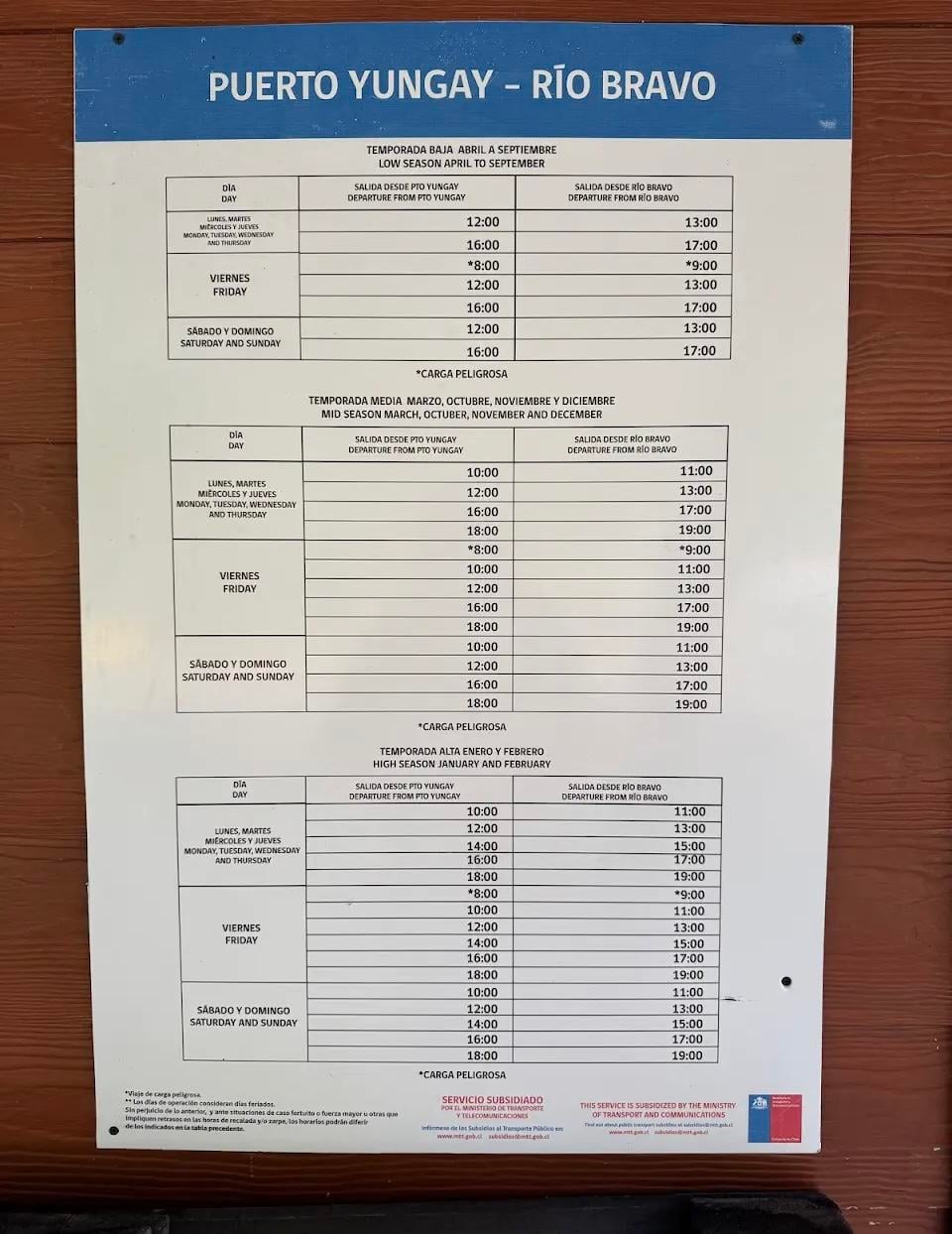
Here’s the schedule for the ferry from Puerto Yungay
See images
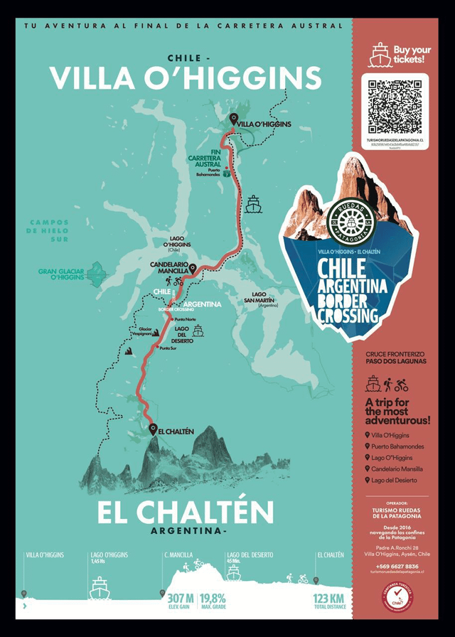
The Lago O’Higgins crossing day was one of our favorites. It takes 15’ per person/couple at border crossing. We got there at 11 and left at noon. It’s rough ripio up to Arg border but trucks use it and the first glimpses of Fitz Rot are very motivating. Then the 7k hike-a-bike single track section. It took us over 2 hrs. There were real or simple downed log bridges over all of the many stream crossings. We didn’t have to ford anything. The downhill trenches are tough. We and the French couple we met in V OHiggins made the 2nd ferry across Lago Desierto all in a day. Our weather that day was perfect, so maybe we were just lucky. Here’s the info about the crossing and arranging the Lago OHiggins ferry:
See images
The ripio from the L Desierto to El Chalten was some of the worst we encountered (especially hard at the end of the long day-ferry ended at 6pm). It took over 2 1/2 hrs to get to El Chalten.
Lodging: We were early on the season, saw only a handful
of other long haul
cycle tourists and stayed primarily in hostels thru Booking.com. We found the Refugio Luna before V OHiggins (no bike wheel on the road, but in the advertised location) was good, the fireplace chimney didn’t work so well. The Pink House wild camp was good-it looked like someone had built a neighboring house, but there was no one home.
We opted to take the preferred BP route to Cerro Castillo (spectacular scenery). There’s an abandoned police station for a wild camp. It’s on a creek but we only used water for cleanup and boiling. We used the Refugio at the Argentine passport control in San Sebastián where there were bathrooms a small kitchen and a heater in the former waiting room. We spoke with 2 cyclists who stayed at the Union bakery in Tolhuin.
The ferry from Punta Arenas to Porvenir is more frequent than the BP guide mentions. Get info on the TABSA website.
We didn’t take the detour to Penguin Bay. If you’re not going to take any other penguin viewing side trips you should consider this one. We opted instead to absolutely fly down the road to San Sebastián in the often mentioned massive Patagonian tailwind. That day we covered 160k in 5 hrs. Some of it in 70kph tailwind.
We decided that this tour was the hardest we’ve done in 7 long trips. The ripio was tough, the weather in the south was cold and damp (more just sprinkles or drizzle than real rain for us), the lack of “amenities” was hard (we only found a handful of cafes for 2nd breakfast on the whole tour), the villages were pretty meager with supplies found in mostly very small mini mercados, wind, especially cross wind, made some days tedious.
We’re glad we did it! Hiking the W in Torres Del Paine was a major bonus.
by Serious_Kangaroo_510